


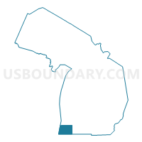
Berrien County PUMA, Michigan
About
Outline

Summary
| Unique Area Identifier | 193173 |
| Name | Berrien County PUMA |
| State | Michigan |
| Area (square miles) | 1,581.47 |
| Land Area (square miles) | 567.75 |
| Water Area (square miles) | 1,013.72 |
| % of Land Area | 35.90 |
| % of Water Area | 64.10 |
| Latitude of the Internal Point | 41.89236190 |
| Longtitude of the Internal Point | -86.73297440 |
Maps

Graphs
Select a template below for downloading or customizing gragh for Berrien County PUMA, Michigan


Neighbors
Neighoring Public Use Microdata Area (by Name) Neighboring Public Use Microdata Area on the Map
- Cook County (Northeast)--Northfield & New Trier Townships PUMA, IL
- Lake County (Northeast)--Waukegan, Zion, Benton & Newport Townships PUMA, IL
- LaPorte County PUMA, IN
- Porter County PUMA, IN
- St. Joseph County (North)--South Bend City PUMA, IN
- St. Joseph County (Outside South Bend City)--Mishawaka City PUMA, IN
- Van Buren & Cass Counties PUMA, MI
Top 10 Neighboring County (by Population) Neighboring County on the Map
- Cook County, IL (5,194,675)
- Lake County, IL (703,462)
- St. Joseph County, IN (266,931)
- Porter County, IN (164,343)
- Berrien County, MI (156,813)
- LaPorte County, IN (111,467)
- Van Buren County, MI (76,258)
- Cass County, MI (52,293)
Top 10 Neighboring County Subdivision (by Population) Neighboring County Subdivision on the Map
- Clay township, St. Joseph County, IN (32,550)
- Michigan township, LaPorte County, IN (27,522)
- Benton charter township, Berrien County, MI (14,749)
- Lincoln charter township, Berrien County, MI (14,691)
- Niles township, Berrien County, MI (14,164)
- Niles city, Berrien County, MI (11,599)
- Benton Harbor city, Berrien County, MI (10,038)
- St. Joseph charter township, Berrien County, MI (10,028)
- German township, St. Joseph County, IN (9,319)
- Oronoko charter township, Berrien County, MI (9,193)
Top 10 Neighboring Place (by Population) Neighboring Place on the Map
- South Bend city, IN (101,168)
- Niles city, MI (11,600)
- Benton Harbor city, MI (10,038)
- St. Joseph city, MI (8,365)
- Fair Plain CDP, MI (7,631)
- Buchanan city, MI (4,456)
- Benton Heights CDP, MI (4,084)
- Paw Paw Lake CDP, MI (3,511)
- Bridgman city, MI (2,291)
- New Buffalo city, MI (1,883)
Top 10 Neighboring Elementary School District (by Population) Neighboring Elementary School District on the Map
Top 10 Neighboring Unified School District (by Population) Neighboring Unified School District on the Map
- South Bend Community School Corporation, IN (160,103)
- Michigan City Area Schools, IN (48,411)
- Benton Harbor Area Schools, MI (30,693)
- Niles Community School District, MI (24,330)
- St. Joseph Public Schools, MI (19,355)
- Lakeshore School District, MI (17,686)
- New Prairie United School Corporation, IN (15,332)
- Dowagiac Union Schools, MI (15,158)
- Berrien Springs Public Schools, MI (13,305)
- Buchanan Community School District, MI (9,918)
Top 10 Neighboring State Legislative District Lower Chamber (by Population) Neighboring State Legislative District Lower Chamber on the Map
- State House District 59, MI (95,808)
- State House District 80, MI (87,871)
- State House District 79, MI (87,693)
- State House District 78, MI (86,900)
- State House District 9, IN (63,447)
- State House District 8, IN (59,962)
- State House District 20, IN (59,794)
- State House District 7, IN (59,426)
- State House District 3, IN (54,541)
- State House Districts not defined, IL (0)
Top 10 Neighboring State Legislative District Upper Chamber (by Population) Neighboring State Legislative District Upper Chamber on the Map
- State Senate District 21, MI (266,141)
- State Senate District 4, IN (141,328)
- State Senate District 11, IN (130,974)
- State Senate District 8, IN (127,082)
- State Senate Districts not defined, IL (0)
Top 10 Neighboring 111th Congressional District (by Population) Neighboring 111th Congressional District on the Map
- Congressional District 1, IN (705,600)
- Congressional District 2, IN (679,254)
- Congressional District 6, MI (671,883)
Top 10 Neighboring Census Tract (by Population) Neighboring Census Tract on the Map
- Census Tract 18, Cass County, MI (8,165)
- Census Tract 109, St. Joseph County, IN (7,754)
- Census Tract 113.02, St. Joseph County, IN (6,522)
- Census Tract 102, Berrien County, MI (6,503)
- Census Tract 110, St. Joseph County, IN (6,434)
- Census Tract 416, LaPorte County, IN (6,330)
- Census Tract 120, Van Buren County, MI (6,105)
- Census Tract 113.03, St. Joseph County, IN (6,098)
- Census Tract 22, Cass County, MI (6,036)
- Census Tract 8, Berrien County, MI (5,312)
Top 10 Neighboring 5-Digit ZIP Code Tabulation Area (by Population) Neighboring 5-Digit ZIP Code Tabulation Area on the Map
- 46350, IN (43,650)
- 46360, IN (43,625)
- 49120, MI (37,122)
- 49022, MI (31,814)
- 46628, IN (25,650)
- 49085, MI (23,804)
- 46637, IN (15,314)
- 49047, MI (14,805)
- 49103, MI (11,082)
- 49127, MI (10,694)